Possible Asteroid Impact Structure In Southeast Missouri
SIMULTANEOUS SUBMISSION
3 February 2020
POSSIBLE ASTEROID IMPACT STRUCTURE IN SOUTHEAST MISSOURI
William Jud, Geologist
Exploration Manager
Legend Minerals LLC
Fredericktown, Missouri
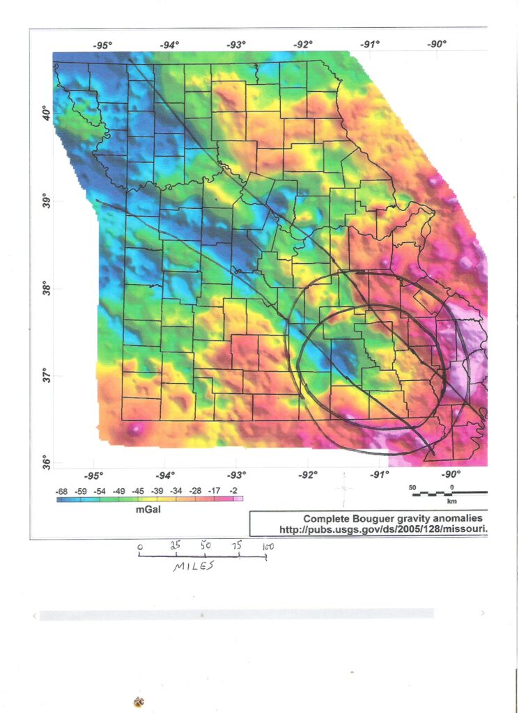
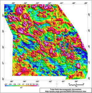
There is a large circular area shown in southeastern Missouri on the Missouri Gravity map. The Missouri Magnetic map does not show this feature. Gravity YES + Magnetic NO indicates the causative agent is deeply buried. It is way too big to be an ancient volcano or another kind of geological structure known in Missouri.
What could it be?
US Geological Survey map, Complete Bouguer gravity anomalies, the Missouri gravity map, shows a circular feature 125 miles wide in southeastern Missouri that suggests this was the impact site 1,500,000,000 years ago of an asteroid at least as big as the Chicxulub asteroid up to 50 miles wide that smashed into Yucatan, Mexico 66,000,000 years ago and killed the dinosaurs.
The Missouri gravity map shows a central region of lower gravity about 112 miles wide surrounded by a fragmented ring of higher gravity extending 13 miles farther outward like a tire on a wheel, a common pattern of large impact sites.
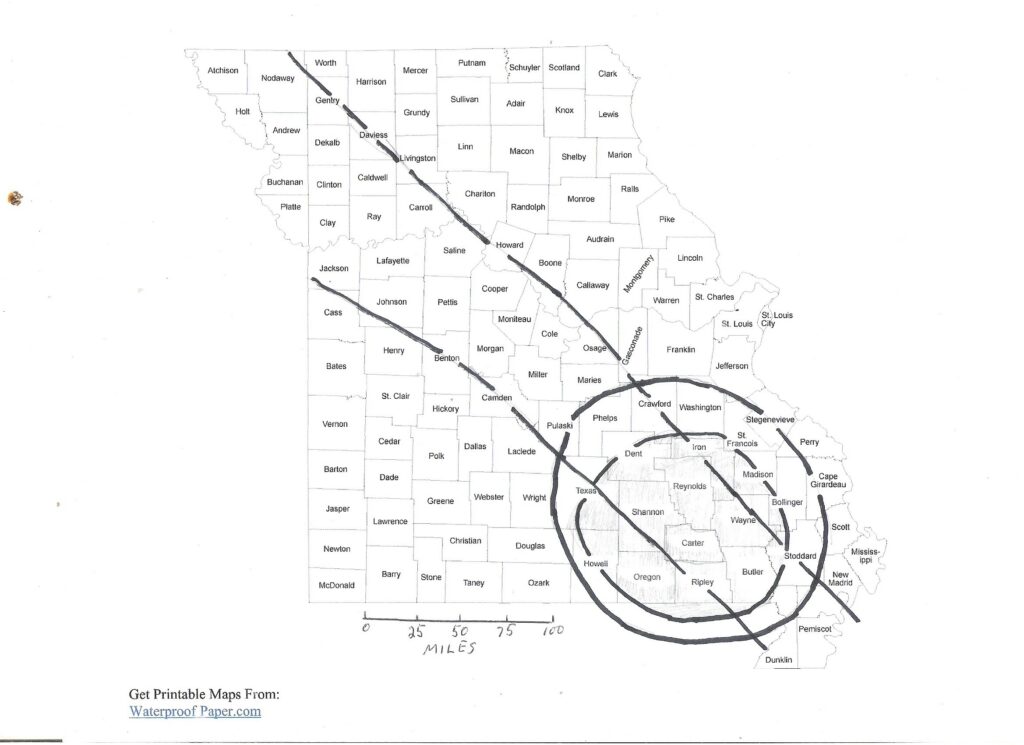
The impact structure extends a little way into northern Arkansas. In Missouri, 23 counties are partly or entirely within the impact area: Bollinger; Butler; Cape Girardeau; Carter; Crawford; Dent; Dunklin; Howell; Iron; Madison; Oregon; Perry; Phelps; Reynolds; Ripley; Scott; Shannon; St. Francois; Ste. Genevieve; Stoddard; Texas; Washington; Wayne. The impact area center is Carter county (Van Buren).
Extending nearly 400 miles northwest from the gravity-indicated impact site in present-day southeastern Missouri to the presumed actual impact site in present-day southeastern Nebraska is a trail 50 to 80 miles or more wide of lower gravity named the Missouri Gravity Low (MGL).
MGL is caused by intrusion into higher density rocks that populate lower regions of Earth’s Crust, of lower density Missouri Batholith granite generated by a Mantle Plume resulting from the asteroid impact. The batholith is estimated to be a vertical slab of buried granite 77 miles wide, at least 372 miles long, and 7 miles thick, with an average depth from land surface to batholith top of about 3 miles.
The lower density granite is ‘floating’ within higher density rocks, causing isostatic adjustment uplift responsible for higher land elevations that have persisted throughout the Ironton and vicinity area since Precambrian time more than a billion years ago. Lower density granite intruded into higher density regional rocks is the geological equivalent of icebergs and low-density wood floating in water.
Mantle Plumes operating today, and similar to but much larger than the Plume caused by the impacting asteroid, power volcanic features at Yellowstone Park and the Hawaiian chain of volcanic islands.
Since impact, tectonic plate motion moved the Crust and the enclosed impact structure 370 miles southeast along the Missouri Batholith trail, separating the asteroid crustal impact structure now in Missouri from the Nebraska impact-generated Mantle Plume in the Asthenosphere uppermost part of the Mantle just below the base of the crust.
Missouri’s iron ores and iron mines in Precambrian rocks in the Washington and Iron counties iron District owe their mineral wealth directly and/or indirectly to the asteroid. Enrichment of cobalt and nickel in Mississippi Valley-type ore deposits at Fredericktown and Mine Lamotte in the Madison County Cobalt District likey is also an indirect result of the asteroid.
 Geological analysis of the gravity map suggests the following history of the asteroid impact event.
Topmost Precambrian rock below the volcanic rock is gneiss (pronounced ‘nice’) and schist. You can see outcropping gneiss and schist (probably a large xenolith) in Hawn State Park east of Farmington, along the Pickle Creek hiking trail upstream from the picnic shelter. These are metamorphic rocks created by heat and pressure from older rocks that could be of any type.
Erosion of these old rocks on the Precambrian paleosurface may have created large, preserved placer deposits enriched with magnetite iron oxide and other dense and durable minerals including the rare-earths mineral monazite.
Gneiss and schist themselves were created from even older, at some point probably sedimentary, rocks that also could contain preserved iron mineral placers and, if old enough to predate an oxygenated atmosphere, a type of globally widespread sedimentary iron deposit called Banded Iron Formation. At any time during this history, igneous activity could have created magmatic iron deposits within any of the host rocks. This pattern could have continued for even more cycles in even older and deeper Missouri Precambrian rocks.
Then WHAM! One day about 1,500,000,000 years ago, a nickel-iron asteroid at least as big as the Yucatan asteroid that killed the dinosaurs slammed into Planet Earth in present-day southeastern Nebraska.
It was not a megadeath event. There wasn’t much to kill. No fish, no land animals, no land plants. Life had developed only to the stage of Cyanobacteria, also called Blue-Green Algae. These would have been killed at the impact site and surrounding area, but not everywhere worldwide. Algae are highly talented at reproduction and would have quickly repopulated the kill zone. Think about how fast algae grows in creeks and ponds as the weather warms at winter’s end.
Impact kinetic energy instantly became high-temperature heat energy. Most of the asteroid and impacted terrestrial rocks vaporized and exploded, scattering debris over a very wide area. Some of the asteroid survived and buried itself deep underground. Some of the impacted rocks also survived and melted into an underground magma ‘pool’.
Magma enriched with iron, nickel, cobalt, rare-earths, and Platinum Group metals including iridium, from the asteroid, formed in the Crust below the impact site and extended a lobe to the east and north under present-day Washington, Iron, and Madison counties. Magma then underwent density differentiation (think Sudbury, Canada) and froze into mafic (rich in magnesium and iron minerals) rock with internal layers enriched with iron, cobalt, copper, nickel, rare-earths, and other elements obtained from both local rocks and from the surviving asteroid fragment.
Impact shock propagated down through the thinner Precambrian Crust and into the underlying Asthenosphere upper Mantle zone starting just below the base of the Crust. Fractures created a permeability column through the Asthenosphere and Crust where gasses, liquids, and magma could enter the Crust and travel upward.
Fractures in the Crust and Asthenosphere also created a zone of permeability and lower pressure that caused decompression melting, created mafic magma injected into the Crustal fracture column possibly as far upward as the impact crater, and set off the circulation of already metastable hot mantle material, starting a Mantle Plume.
The Mantle Plume was relatively small, local, rootless, and short-lived, but powerful. Think of the Plume as an enormous geological welding torch aimed at the Crustal base.
Plume circulation was a magma-generating conveyor bringing hotter, deeper Mantle material upward and into contact with the Crustal base, melting the lower and possibly middle Crust and mobilizing gasses, metals, and other rock chemicals and propelling this material upward toward areas of lower temperature and pressure at the surface.
Thus began intrusion of Missouri Batholith granite that created the Missouri Gravity Low.
Enter Plate Tectonics moving Crustal rocks southeast.
As the Mantle Plume continued melting older rocks of the lower and possibly middle Crust, Plate Tectonics pushed overlying Crustal impact host rocks off of the underlying Asthenosphere impact area of melting.
Instead of forming a large ball of granite above the Mantle Plume, rising magma was strung out southeastward by Plate motion, like material being continuously deposited on a moving conveyor belt, leaving a trail of Missouri Batholith granite 370 miles long.
As Missouri Batholith granite magma intruded upward, high areas of magma called cupolas broke through to the surface and created Precambrian volcanoes of the multi-state St. Francois volcanic province.
This volcanic feature is exposed in Iron and Madison counties but mostly buried elsewhere under younger sedimentary rocks. Lack of widespread exposure complicates geological study.
Elephant Rocks State Park near Ironton exposes the frozen magma chamber of a Precambrian volcano.
The Crustal impact structure led the southeastward parade. Gravity map features at the impact site are sharply defined and igneous features the most intense. As the Crust continued moving southeast the mini-Mantle Plume slowly lost energy and fizzled out. Magmatic intrusion became less energetic. Features on the gravity map become wider, weaker, and ‘fuzzier’.
The Grand River Tectonic Zone (GRTZ) is a right-lateral Continental Transform Fault on the east side of the batholith, and similar to the San Andreas fault in California. A branch of GRTZ in Madison county shows 18 miles of right-lateral horizontal offset, moving rock formerly at Ironton into position south of Fredericktown.
Frequent reactivation of GRTZ from Precambrian time (1,500,000,000 years ago) to Pennsylvanian time (300,000,000 years ago) provided an ongoing underground route for migration of gasses and hydrothermal fluids that caused mild regional alteration of Precambrian volcanic rocks. GRTZ offered sites where warm, rising, mineralized hydrothermal fluids could meet and mix with cold, oxygenated, descending meteoric water in geochemical cells under conditions favoring deposition of ore deposits.
Early in the tectonic movement process, the Mantle Plume came into alignment with a Crustal area already enriched with iron. As mentioned, pre-existing iron enrichment had several possible sources, including a surviving asteroid fragment and impact-generated and differentiated frozen magma.
As the Mantle Plume melted lower and middle Crust some of the pre-existing iron was mobilized and transferred to higher Crustal levels of lower pressure and temperature to become Precambrian hematite and magnetite iron ore deposits in Iron and Washington counties and vicinity.
Cobalt and nickel enrichment by the asteroid in the Madison County Cobalt District followed a more indirect path.
Cobalt and nickel from the asteroid first were moved into and enriched nearby Precambrian rocks. Then, much later during (probably) Mezozoic time when dinosaurs were stomping around Missouri, migrating warm hydrothermal fluids scavenged cobalt and nickel from locally enriched Precambrian rocks and added the metals to Mississippi Valley-type lead deposits of the Madison County Cobalt District at Fredericktown and Mine Lamotte.
A good story so far. Is there any way to verify the model?
Verification will be difficult due to multiple destructions of evidence and the deep location of the impact structure and any surviving asteroid fragments.
The first destruction of evidence was the impact. Although there was a lot of iridium in the asteroid, most of the asteroid and impacted earth rock vaporized and exploded when the collision occurred. Debris scattered widely, hundreds to thousands of miles from the crater, and instantly took most of the asteroid’s iridium with it. Unlike the Chicxulub crater event, the primitive state of life on earth (only Cyanobacteria) did not produce a recordable worldwide life extinction, Also unlike Chicxulub there likely are no available Precambrian sedimentary rocks that would display a brief increase of iridium as happened with the dinosaurs extinction event.
If there is a surviving piece of the asteroid, and residual iridium in terrestrial rocks within and around the crater, the iridium is in the upper Crust, not at the Crustal base where the Mantle Plume was melting ancient rock and creating magma. Iridium in the impact crater and vicinity was not directly involved in melting and mobilization caused by the Mantle Plume.
 The Gravity map shows that Missouri Batholith granite magma intruded the impact crater. That rearranged the impact crater’s geochemistry, blurring details.
Missouri Batholith granite magma broke through to the surface at high points called Cupolas and created the multi-state St. Francois volcanic field. The first eruptions, preserved at the bottom of the volcanic rock pile and within the area enclosing the impact structure, would have absorbed and retained the most iridium from the impact structure. Later volcanic magma eruptions when the impact structure had moved farther southeast would not have passed through the impact structure and would not have absorbed iridium from the impact structure. Earliest volcanic eruptions of magma that passed through the impact structure and would contain the most iridium still exist after erosion removed the upper 1 to 2 miles thickness of volcanic rocks after Precambrian volcanic activity stopped.
As a further complication, Precambrian iron deposits in Iron and Washington Counties may have been created by magmatic/hydrothermal mobilization of much older iron deposits that did not receive iron from a surviving asteroid fragment.
Is there any hope of resolving the asteroid impact issue?
The cluster of Precambrian iron ore deposits in Washington and Iron counties is suggestive. Enrichment of cobalt and nickel in the Madison County Cobalt District is suggestive.
What would help verify the model is the discovery of widespread regional distribution and enrichment of IRIDIUM along the southeastern third of the Missouri Gravity Low, in the asteroid impact structure, in associated earliest volcanic rocks, and in local Precambrian iron and Mississippi Valley-type cobalt-nickel mining areas. But remember, most of the iridium was blown away during impact so there was very little left for the enrichment of local Precambrian rocks.
Drilling into the crater to sample the structure and geochemistry would likely be impractically deep, expensive, and without economic mining incentive.
 Iridium often geologically travels with iron. Probably the best available geochemical test for an asteroid impact would be mapping iridium concentration in Iron and Washington Counties Precambrian iron deposits such as Pilot Knob and Pea Ridge. These iron deposits are within the outer circle of a proposed asteroid impact on the Gravity map. A positive iridium anomaly in Precambrian iron deposits would suggest an asteroid impact.
Iridium is a chemical element, a metal, and part of the Platinum Group. There is a steady, extremely light rain of Iridium falling from the sky as micrometeors and larger metallic space rocks enter our atmosphere and burn up.
Iridium is present in terrestrial igneous rocks at a concentration of around 0.001 part-per-million (ppm). That’s a concentration of 1/1,000 gram per metric ton (1,000 kilograms) of rock. Can you even see something that weighs 1/1,000 gram?
Iridium in metallic space rocks is 500 times more concentrated at 0.5 ppm.
If the analysis of earthly rocks turns up a high concentration of iridium start searching nearby for a space rock impact structure. If Precambrian iron deposits of igneous origin, and the surrounding region, are enriched with iridium that’s really good evidence of an asteroid impact.
Enriched iridium in the impact structure would be the best evidence. Unfortunately, the impact structure is buried under Precambrian volcanic rocks and younger marine sedimentary rocks and is not exposed to study. There is a lack of deep enough existing drill holes to provide rock samples.
Also, unfortunately, the popular X-Ray Fluorescence (XRF) handheld instrument that geologists use for quick-ZAP chemical analysis of rocks has an iridium lower limit of detection higher than the iridium concentration in terrestrial rocks and space rocks, so XRF won’t work. Iridium analysis must be done by more sensitive and expensive methods such as Neutron Activation Analysis (NAA)
With NAA a prepared sample of rock is put into an operating nuclear reactor until the sample becomes radioactive. Then the sample is removed and allowed to age for enough time that overall radioactivity decreases enough to allow the signal from the desired element to optimize relative to background noise from other elements in the sample. Analyzing the optimized signal determines element content with greater sensitivity that includes the usual range of iridium in rocks.
Could there be economic benefits? Yes and no.
The good news. Geology is favorable.
A huge southeast Missouri asteroid impact crater, 112 miles wide and 12 miles deep, filled with permeable, reactive rubble, at the top end of a hydrothermally active fracture column going all the way down into the Asthenosphere and into a Mantle Plume, is a 5-STARS textbook condition for the creation of massive ore deposits.
A zone of chemical alteration 400 miles in length along GRTZ is another 5-STARS environment for the creation of massive high-tonnage/low-grade ore deposits. The recent EarthScope Magnetotelluric survey found a deep zone of high electrical conductivity along GRTZ that indicates graphite or sulfide mineralization.
The bad news. The mineral deposits may be too deep to mine.
This asteroid study is likely to discover mineral deposits. But a MINERAL deposit is just an accumulation of minerals. An ORE deposit is a mineral deposit that can be mined and sold at a profit.
A ton of gold nuggets piled on your front yard on Earth is a rich ore deposit. That same ton of gold on Mars would just be a mineral deposit because of the extreme transportation cost to bring the gold home to market.
Depth is a factor. A rich gold deposit at the surface is an ore deposit. The same gold deposit 10 miles deep underground is just a mineral deposit because mining can not go that deep and if it could the cost would far exceed the gold value.
Since large scale volcanic activity in Missouri stopped more than a billion years ago, erosion removed 1 to 2 miles thickness of Missouri Precambrian volcanic rock. That brought any deeply buried Precambrian ore deposits closer to the surface and reduced mining depth. Any ore deposits within the eroded rocks were lost.
Deposition of sedimentary rocks since the sea moved onto Missouri about 550,000,000 years ago added more mining depth over any buried Precambrian ore deposits.
So let’s treat this as an exciting scientific investigation that hopefully could provide some economic benefit. That’s the way science is supposed to work.
William Jud
For additional general information visit the Legend Minerals website.
For unedited and sharper-imaged Gravity and Magnetic Missouri state maps, on the Legend Minerals website go to Areas of Focus.