Supporting Research
- The last paragraph on Page 69 validates my ASTEROID IMPACT MODEL. See NUMBERED PAGES 67-68-69, and in particular the final paragraph on page 69. There are more Total Pages than Numbered Pages. LOW DENSITY BODIES could include BURIED, DEPLETED ASTEROIDS. Gravity and Magnetic Investigations into Possible Economic Mineral Deposits within the Northwest St. Francois Terrane, Southeastern Missouri
- Are You Looking For Asteroids to Mine? Look Down
- ASTEROID Mining … In Southeast Missouri?
- VIDEO INTERVIEW: Asteroid Mining … In Southeast Missouri?
- Possible Precambrian Asteroid Impact Structure In Southeast Missouri
- United States Geological Survey Bulletin 1932 (The Midcontinent of the United States. Permissive Terrane for an Olympic Dam-Type Deposit?) – Click to View
- Selected Excerpts from William Jud’s Proprietary Geological Report (no maps or specific locations included) – Click to View
- Aerial Geologist – Click to View
- ThREE Consulting – James Kennedy provides consulting services to the financial, mining and nuclear energy industry on strategic issues related to Rare Earths, Thorium and the U.S. regulatory environment.
Research Articles:
- Rare Earth Cooperative 21st Century Manufacturing Act
- Iron Oxide Copper – Gold mineral system
- Granite-Related Mineral System
- Mafic-ultramafic orthomagmatic mineral systems
- Iron Oxide Copper Gold Ore Deposits
- China’s Heavy Production Monopoly and List Map of Countries in Mining Rare Earth Element (REE)
- Rare Earth Element
- Rare Earth Minerals in the World and in Missouri
- Rare Earths in Review – A Decade of Decline & Deception
- SELLOUT Book by Victoria Bruce – A Review by William Jud
- Rich, attractive and extremely dense – A geophysical review of Australian IOCGs
- Rich, attractive and extremely shallow – USGS seeks eligible mineralization
- Southeast Missouri Regional Airborne Geophysical Survey 2018-2019
- Crustal architecture beneath the southern Midcontinent (USA) and controls on Mesoproterozoic iron-oxide mineralization from 3D geophysical models
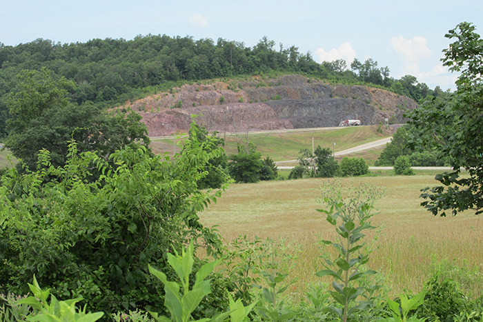
This highway cut on Highway 67 at the intersection with Highway E near Fredericktown, Missouri, exposes rhyolite and ignimbrite (fused volcanic ash) Precambrian age rock. At both ends of the cut a little overlying Cambrian age Bonneterre Formation dolomite rock is exposed. The rock in this cut is highly faulted because this location is right up against the Grand River Tectonic Zone (GRTZ) continental Transform Fault with an estimated 18 miles of right-lateral displacement. Right-lateral displacement means that regardless of which side of the fault you stand on, the other side moved to the right. Highway E at the left (south) end of the cut is where GRTZ passes through and goes under the bridge. This also is the east side of a large Graben that extends between GRTZ and the Central Missouri Tectonic Zone fault to the west. The valley that begins at GRTZ on the south side of the highway cut is actually several hundred feet deep on the Precambrian paleosurface but is filled with Cambrian marine sediments so there is little present topographic relief. GRTZ extends completely across Missouri in a northwesterly direction and connects the Reelfoot Rift in the southeastern Missouri bootheel with the Midcontinent Rift in Kansas, Nebraska, Iowa and points farther north and east. These rifts are places where North America tried but failed to split apart. Reelfoot Rift is still trying, as evidenced by the many recent earthquakes in the Reelfoot Rift Seismic Zone.
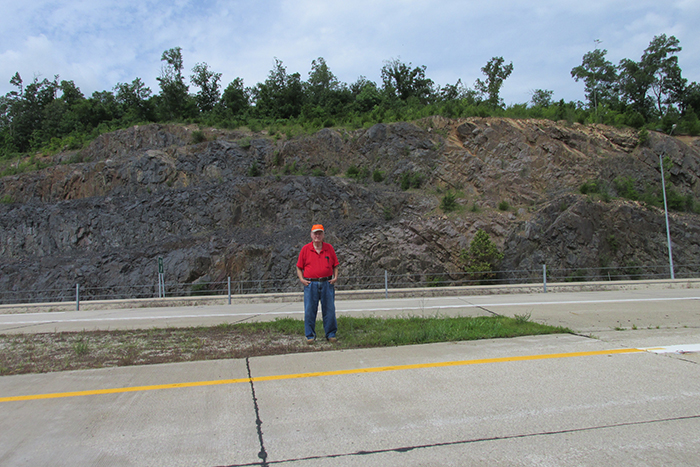
Legend Minerals’ Exploration Manager William Jud standing in front of highly faulted Precambrian volcanic rocks exposed in the highway cut on Highway 67 at the intersection with Highway E near Fredericktown, Missouri. Exposed rock is complexly faulted due to close proximity to the Grand River Tectonic Zone (GRTZ) continental Transform Fault. When the rock here dries after rain a temporary white efflorescence forms, most likely due to precipitation of Gypsum from a weak outlier of nearby Mississippi Valley-Type sulfide mineralization that formed ore deposits of lead, zinc, copper, cobalt, nickel and iron in Cambrian Bonneterre dolomite in the nearby Cobalt District at Fredericktown and Mine Lamotte. Now buried under the road, highway construction exposed a small Precambrian hot spring feeder structure that deposited Siderite and Gypsum. These materials were examined for any fossils of bacteria and other early life forms, but nothing was found. The volcanic rock breaks into sharp, glass-like fragments that cause a lot of cut fingers and sliced tires, probably due to silica enrichment.
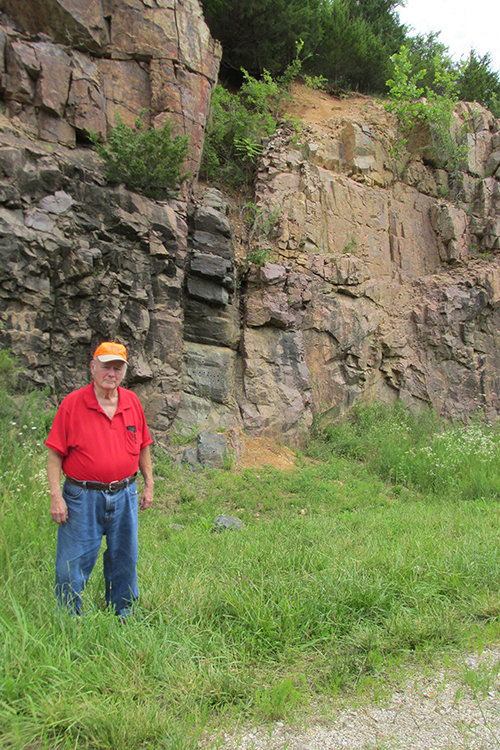
A dark-colored Diabase Dike intruded volcanic rock in a highway cut on Highway 72 about three miles west of Fredericktown, Missouri. Chemically basic Diabase and Gabbro magmas were the last verified and widespread igneous intrusive event here during Precambrian time, 1.0 to 1.5 billion years ago. There is indirect and sketchy evidence that the final widespread igneous intrusive event may have been emplacement of Spavinaw Granite, but this rock does not outcrop locally and has not been recovered in exploration drill holes locally. Halfway between Highways E and 72, on the north side of the valley where the river cuts through the ridge west of Highway 67, is a dike of Diabase Porphyry locally called ‘Devonite’, that is a multiple intrusion with crystals of partly resorbed Feldspar up to three inches wide. This has been a popular rock specimen collection spot for many years and reportedly is all collected-out.
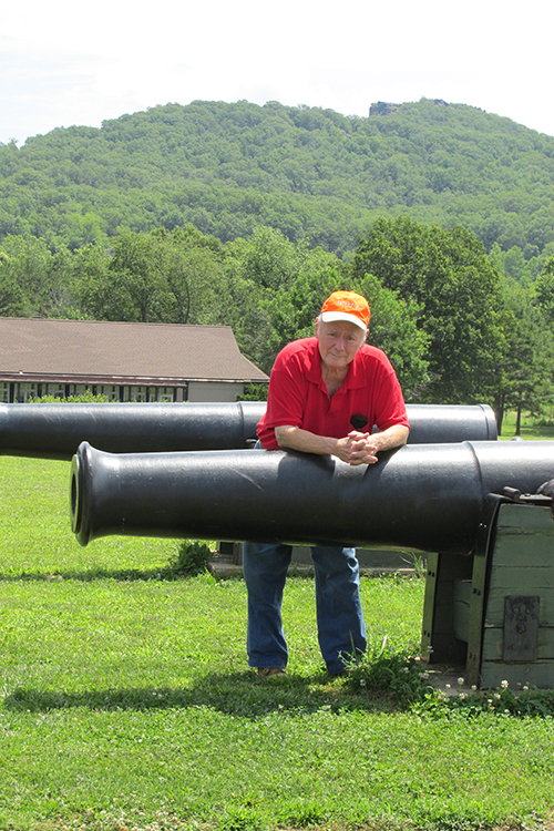
The notch at the top of the hill is the historic Pilot Knob iron mine. The mine is bigger than it looks in this picture. Abundant summer vegetation is hiding almost all of the mine. This Upper Pilot Knob iron ore deposit is in waterlaid volcanic ash in a caldera lake at the top end of an Olympic Dam-type iron mineralizing system and had hot springs and fumaroles. Mineralization was by replacement of volcanic ash and is largely Hematite with minor Barite. The volcanic ash has cross-bedding, ripple marks, and relict impressions of rain drops, hail, and salt crystals. At depth below the bottom of the hill is the Lower Pilot Knob iron ore deposit, a deeper phase of an Olympic Dam-type ore mineralizing system, and is largely Magnetite massive and breccia ore. The building is a nice Civil War museum. The cannons are part of Fort Davidson Historic Site at Pilot Knob where an important Civil War battle was fought. Union troops were surrounded by Confederates but managed to escape at night during a fierce rain storm and made their way north to join Union army forces at St. Louis.
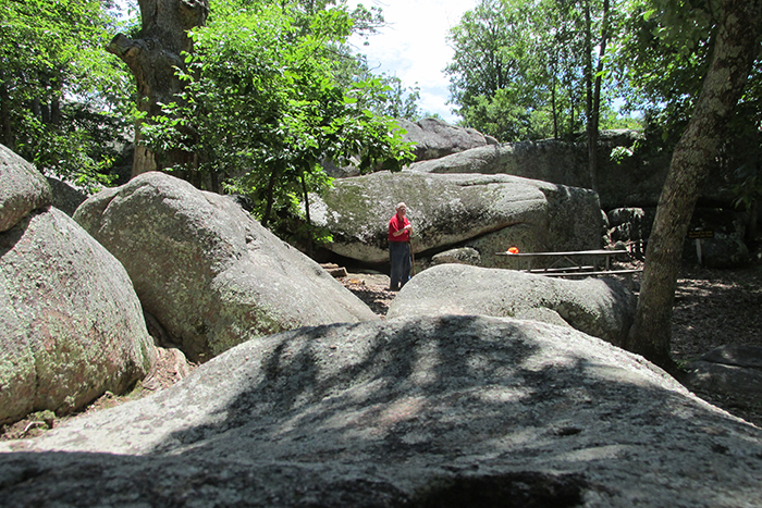
Elephant Rocks State Park on Highway 21 near Graniteville features large exhumed Granite rocks rounded by weathering. This is the frozen magma chamber of a big Precambrian volcano. Decompressive forces caused by erosion of overlying rock made vertical and horizontal joints form in the Granite and weathering rounded the exposed rocks. There is a large commercial Granite quarry nearby at Graniteville. Big blocks of Granite are cut from the ground, sawed into thick slabs, and sent away to become tomb stones, counter tops and other attractive and durable stone items. The Grand River Tectonic Zone (GRTZ) continental Transform Fault passes by the northeast side of the quarry and sliced off some of the Granite, moving the missing rock an estimated 18 miles of right-lateral displacement southeast toward Fredericktown. Faults also can have motion that is left-lateral, vertical and horizontal. The Graniteville Granite formed when a hot Precambrian Mantle Plume underplated and melted crustal rocks. Partial melting of crustal rocks and fractionation of chemical elements enriched the magma with Potassium, Thorium and Uranium, and produced red Granite and associated volcanic rocks also enriched with those elements. Graniteville Granite is composed almost entirely of Quartz and Orthoclase Feldspar. Regionally, magma created by the Mantle Plume formed the Missouri Batholith and the associated Missouri Gravity Low in which gravity intensity is lower than in surrounding areas.

This is a photo of fresh Granite in one of the Graniteville Granite boulders at the parking area at Elephant Rocks State Park. A one-mile trail winds through the Park and passes by an old Granite quarry, an old railroad maintenance building with walls made of Granite, and the ‘Elephants’ which are large rounded rocks perched atop a Granite outcrop. The trail is signed in Braille at several places, explaining Park features for people who have a visual problem reading ordinary printed signs.